
The shipping channel at Outer Harbor, Port Adelaide, is a busy hub that sees hundreds of trade and cruise vessels come and go each year, transporting goods and tourists into and out of South Australia.
The Port was facing future challenges with infrastructure unable to accommodate the global trend of shipping liners using larger, more economical vessels. There was a need to widen the channel and swing basin to maintain competitiveness with other Australian capital city Ports – most of which were already able to accommodate wider Post Panamax vessels without operational restrictions.
If the channel was not widened, there was a risk that containerised trade and cruise ships would “skip” Adelaide and use alternative Ports. This would create a negative impact on the South Australian economy due to an increased cost to transporting imports and exports and a reduced revenue from cruise liners.
In May 2018, the State Government granted Flinders Ports development approval to widen the Outer Harbor shipping channel. From there the following events occurred:
- July 2018, Flinders Ports applied for a dredging licence through the Environment Protection Authority (EPA)
- October 2018, Flinders Ports began engaging with stakeholders and community for the project
- November 2018, public consultation by the EPA occurred
- January 2019, Native Vegetation Clearance permit was granted via the Department of Environment and Water (DEW)
- March 2019, the dredging licence was issued by the Environment Protection Authority SA (EPA)
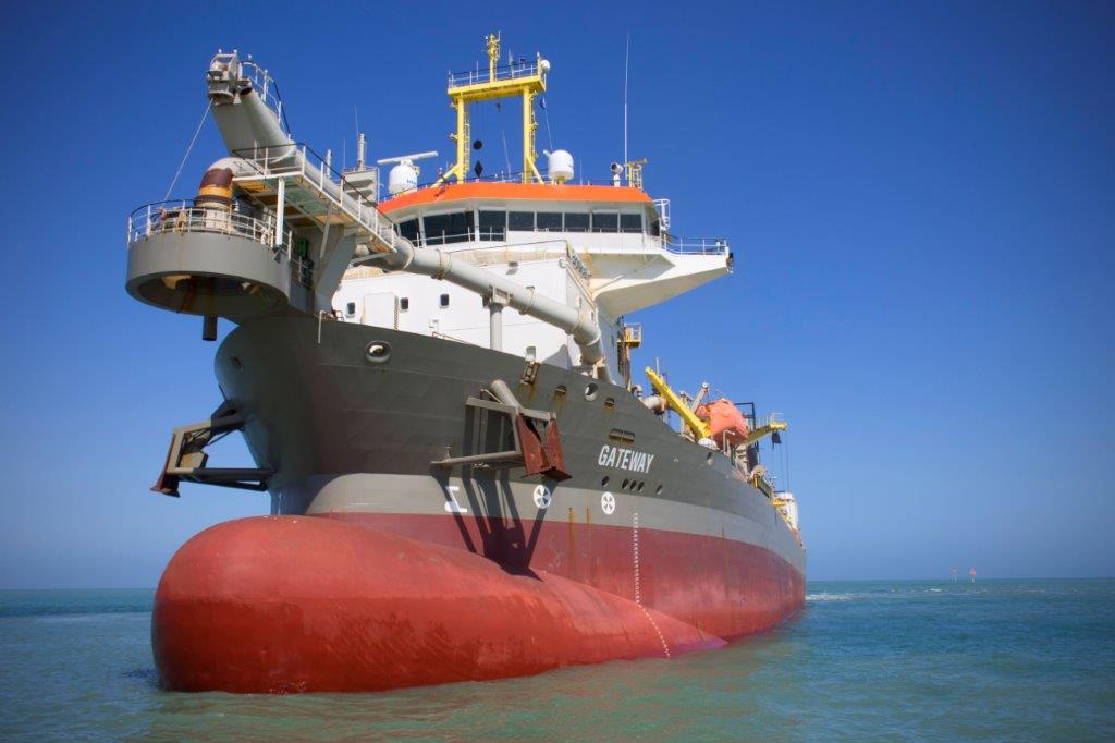
- March 2019, internationally recognised dredging and marine expert Boskalis was appointed to carry out the work
- June – September 2019, dredging occurred
- October 2019, the project was complete
The widened channel can now accommodate container ships and cruise ships with a maximum width of 49 metres without operational restrictions. Other key facts about the project include:
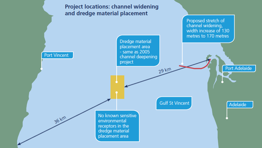
- The shipping channel was widened from 130 metres to 170 metres
- The swing basin was widened from 505 metres to 560 metres
- Dredged material consisted primarily of shelly sand and silt, with some clays and limestone
- Dredged material was placed 30km offshore in the Gulf St Vincent – the preferred option determined following thorough investigation (see map below)
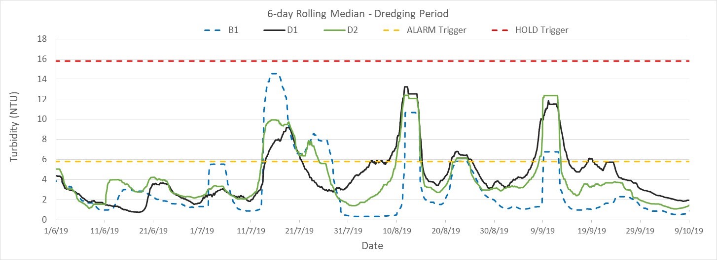
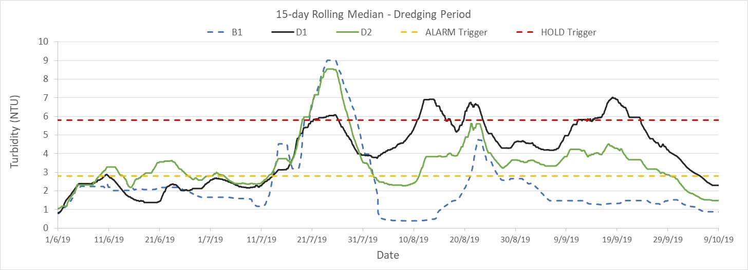
- Thorough environmental monitoring informed dredge activities
- Worked closely with key government agencies to satisfy regulatory conditions and meet State Government objectives
- Ongoing reporting to the EPA
- Ongoing stakeholder and community engagement
Project Management
A key step in the project was obtaining a licence through the EPA and a permit for native vegetation clearance from DEW.
EPA Dredging Licence
The licence was granted under the Environmental Protection Act 1993 and incorporated conditions to meet various issues raised through community and stakeholder submissions.
The marine environment was closely monitored before, during and after dredging to enable any risks to be identified and interventions to be applied.
Flinders Ports regularly reported to the EPA on management and monitoring activities associated with the dredging. Monitoring data was also available for public access on our website.
Additional conditions were set for the dredge method, environmental management and monitoring, turbidity management, seagrass management and monitoring, Dredge Management Plan, POMS Management Plan, biosecurity and the Dolphin Sanctuary.
Native Vegetation Clearance permit
The Department of Environment and Water approved a Native Vegetation Clearance permit, allowing Flinders Ports to clear a small amount of sparse seagrass (approximately 4ha) as part of the expansion of the Outer Harbor channel.
The permit accepted that up to 158ha of seagrass would potentially be indirectly affected in the short-term and initial disturbance to seagrass was expected to recover post dredging.
Dredge Management Plan (DMP)
Flinders Ports developed a Dredge Management Plan, approved by the EPA, which outlined how conditions of the Dredging Licence and Native Vegetation Clearance permit would be met.
The DMP aimed to guide the dredge methodology, and management of potential environmental risks associated with dredging, including:
- Dredging
- Vessel movement
- Dredged material placement
- Vessel management (e.g. bunkering, ballast water exchange)
Biosecurity
The EPA, Primary Industries and Regions SA, DEW and the South Australian Research and Development Institute worked closely with Flinders Ports to develop a dredge methodology that would minimise impact to the marine environment.
Dredge contractor
World-leading dredging and marine specialist Boskalis was appointed to undertake the dredge works for the project
With more than 100 years’ experience in hydraulic engineering, coastal protection and land reclamation, Boskalis followed the Dredge Management Plan, using state-of-the-art equipment to minimise environmental impact.
Community engagement
Ongoing community and stakeholder engagement was a key priority for the project. A Community Engagement Plan was developed to guide activities and ensure a structured and strategic approach which kept the community informed and actively part of the process at key milestones.
Consultation began prior to the licence being issued, which helped inform pre-dredging planning, and continued until project closure, assisting with feedback throughout the project.
Ongoing communication included:
- Information briefings and sessions with individuals, groups and the community
- Regular updates at key milestones via email, social media, letterbox drops and the website
- An opportunity to engage with the project team in person, via a hotline or email
A complaints policy and register were developed to support the management and resolution of enquiries, including regular reporting back to the EPA on issues raised.
Monitoring and Reporting
Environmental monitoring and reporting was conducted throughout the project to inform dredging activities and ensure minimal impact to marine life.
Measures taken and monitoring conducted were outlined in the EPA Dredge Licence, the Dredge Management Plan and Environmental Monitoring Program. Monitoring data can be found in the EPA monthly reports below.
Live water quality monitoring data was available on our website throughout the project to help the stakeholders and the community understand activities in the water and associated environmental effects.
Resources
Please find below various resources relating to the Outer Harbor Channel Widening Project.